Typhoon

Case study - Typhoons in the world
1961-2018
Typhoon Nancy (1961)
Date: September 7 - September 22, 1961
Highest wind speed: 345km/h (215mph)
Lowest pressure: 882 hPa (mbar); 26.05 inHg
Fatalities: 172-192 direct
Damage :$500 million (1961 USD)
Areas affected: Guam, Ryūkyū Islands, Japan
-
An extremely powerful tropical cyclone of the 1961 Pacific typhoon season and one of the most intense tropical cyclones on record. The system possibly had the strongest winds ever measured in a tropical cyclone, tied with Hurricane Patricia of 2015. It caused extensive damage and at least 173 deaths and thousands of injuries in Japan and elsewhere in September 1961.
-
A tropical depression formed from a low near Kwajalein Atoll on September 7. It strengthened rapidly; by the time position fixes could be taken, Nancy was nearly a super typhoon. Moving gradually westward, Nancy explosively deepened on September 9.
-
Shortly after reaching peak intensity, Nancy approached the Ryūkyū Islands and began turning. It passed near Okinawa and over Haze. The ridge steering Nancy broke down, and the typhoon turned sharply and headed towards Japan. Nancy made landfall as a strong typhoon on September 16 as it passed directly over Muroto Zaki. Nancy made a second landfall on Honshū near Osaka.
-
The typhoon rapidly traveled up the length of the island as it continued accelerating, eventually reaching a forward speed of 65 mph (100 km/h, 55 knots).The typhoon quickly crossed over Hokkaidō before entering the Sea of Okhotsk as a tropical storm. Nancy went extratropical on September 17. The extratropical system eventually crossed over Kamchatka and entered the open ocean.


Typhoon Sally (1964)
Date: September 2, 1996 – September 9, 1996
Highest wind speed: 314km/h (195mph)
Lowest Pressure: 940 hPa (mbar); 27.76 inHg
Total fatalities: 140 fatal, 130 missing
Damage: $1.5 billion
Affected areas: Vietnam, China, Philippines
-
Typhoon Sally was formed on Sept. 3, 1964, near Ponape. It moved west, reaching typhoon status by the next day and super typhoon status by the 6th. Its peak winds reached 195 mph (314 km/h), becoming the strongest typhoon of the season on the 7th.
-
Sally made landfall in the Philippines on the 9th as a Category 4 typhoon and then continued to make landfall in south China as a 115 mph (185 km/h) typhoon on the 10th, dissipating over land that same day.
-
Tropical Depression 27W formed on September 3 near Ponape as a 30 mph (48 km/h) depression. 27W quickly strengthened and was given the name Sally the same day. Rapid strengthening occurred as Sally moved west, reaching typhoon status by September 4, super typhoon status by the 6th and its peak intensity of 895 mbar with 195 mph (314 km/h) winds, becoming the strongest typhoon of the season on the 7th. Sally made landfall in Philippines on the 9th as a Category 5 typhoon. Weakening occurred and made landfall in China as a 115 mph (185 km/h) typhoon on the 10th, dissipating over land the same day.

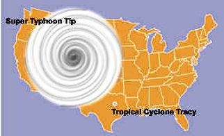
Typhoon Tip (1979)
Date: October 4 – October 24, 1979
Highest wind speed: 305 km/h
Lowest pressure: 870 mbar (25.69 inHg)
Total fatalities: 99
Damage: unknown, but estimated at least several million dolllars
Affected areas: Japan, Philippines, Alaska, Guam, Northeast China,
Russian Far East, Caroline Islands
-
Typhoon Tip hit Guam and Japan with a speed of 190 mph (305 km/h) on Oct. 12, 1979. It formed out of a disturbance in a monsoon on the 4th near Pohmpei, and dissipated on the 19th. Tip was the 12th typhoon and 19th tropical storm of the 1979 Pacific typhoon season.
-
Around 100 people were killed and damages for the agricultural and fishing industries came to millions of dollars.
-
Typhoon Tip was among the most closely observed tropical cyclones. U.S. Air Force Reconnaissance flew into the storm 40 times and produced 60 storm fixes.
-
According to formal records, Typhoon Tip was the most intense tropical cyclone ever observed (with a central pressure of 870 mbar). It is unsure if Tip still holds this record due to unconfirmed reports of lower central pressures in other typhoons. It is believed that typhoons Gay (1992) and Angela (1995) and also Australian Cyclone Monica may have been slightly more intense.
-
Had the typhoon struck very populous, southern Japan at or near peak intensity, mass destruction would have likely resulted. Though Tip was such an impressive metrological event, the impact of the storm was not severe enough to have the name retired; “Tip” has been reused three times since 1979.
Typhoon Maemi (2003)
Maemi (Definition: Cicada)
Date: September 5 ~ September 16 ,2003
Highest Wind Speed: 278km/h (75m/s)
Lowest pressure: 950 hPa (mbar); 28 inHg
Total Fatalities: 135 (Korean: 132, Japanese: 3)
Damaged: 4.3 billion dollars (Similarly equal to half-sized of
IBK Industrial Bank’s aggregate value of listed stock)
Affected areas: South Korea, North Korea, Taiwan,
Okinawa Prefecture, Miyako-jima
-
The typhoon, Maemi, occurred from September 5 to September 16 in 2003. This typhoon was formed during monsoon period in western Pacific Ocean. Majority of meteorologists firstly predicted that the typhoon Maemi would be a middle-sized typhoon, but it became the strongest level of typhoon and severely attacked in Korea and Japan around September 12 and produced astronomical damaged cost.

Typhoon Bolaven (2012)
Bolaven (Definition: Bolaven Plateua in Laos)
Date: August 19 - Sepctember 1 ,2012
Highest Wind Speed: 241km/h (65m/s)
(The second strongest among the level of typhoon category)
Lowest pressure: 910 hPa (mbar); 26.87 inHg
Total Fatalities: 88
Damaged: 0.475 billion dollars
(Similarly equal to Ssangyong Automobile’s aggregard value of listed stock)
-
The typhoon, Bolaven, occurred from August 19 to September 1 in 2012. This typhoon was formed near Mariana Islands. Bolaven specifically gave a big damage to the Philippines and also severely stroke in Korea Peninsula. A lot of meteorologists expected this typhoon will direct to China, but it changed a direction to Korea and gave a huge influence both for South and North Korea.

Typhoon Sanba (2012)
Typhoon sanba 2012 = Typhoon karen
Date: September 10 - September 19 , 2012
Highest winds sustained: 285km/h (180mph)
Lowest pressure 900 hPa (mbar); 26.58 inHg
Total fatalities 6
Damage $378.8 million (2012 USD)
-
Typhoon Sanba, known in the Philippines as Typhoon Karen, was the strongest tropical cyclone worldwide in 2012.
-
On September 10, Sanba formed as a tropical depression east of The Philippines . The storm gradually intensified as it moved generally northward. The system was soon upgraded to a tropical storm less than a day after formation and subsequently further to a typhoon on September 12.
-
On September 13, the system attained its peak intensity with maximum sustained winds of 125 mph (205 km/h), and a barometric pressure of 900 mbar (hPa; 26.58 inHg), becoming the strongest typhoon in the Western Pacific Ocean since Megi in 2010. Accelerating towards more northerly latitudes, a period of gradual weakening ensued afterwards as its eye expanded.
-
On September 16, the eye of Typhoon Sanba was located just north of Okinawa, Japan. Sanba was moving toward the Korean Peninsula, and storm clouds already extended over that peninsula.
-
On September 16, the U.S. Navy’s Joint Typhoon Warning Center reported that Sanba had maximum sustained winds of 90 knots (165 kilometers per hour) and gusts up to 110 knots (205 kilometers per hour). Although wind speeds had declined considerably over the previous few days, Sanba remained a powerful typhoon.


Typhoon Haiyan (2013)
Date: November 3 – November 11, 2013
Maximum wind speed: 315 km/h
Lowest pressure:
Total fatalities: 6,340
Damage: $14 billion Philippines economy
Affected nations : Philippines, Caroline Island, South China,
and Vietnam
-
Typhoon Haiyan mainly affected Philippines by making landfall
-
The most powerful typhoon in 2013 and categorized as “super typhoon” with sustained winds of 195mph
-
It was large in diameter which stretches more than 1,850 kilometers (1,150 miles)
-
It affected over 16 million people across 44 provinces, displacing 4.1 million people and killing more than 6,000people
-
It made landfall in the province of eastern Visayas, disrupting communication with a major city in its path
-
Tacloban City on the Leyte island was 90 percent destroyed.

Typhoon Megi (2016)

Date: September 23 - September 25, 2016
Maximum Wind Speed: 110 mph
Lowest pressure:
Total fatalities :24
Damage: $ 1.57 billions
Affected nations: China, Taiwan, Caroline Islands, Ryukyu Islands

Impact in Taiwan
-
Category 4 rainfall in Taiwan
-
It was one of most damaging typhoons that affected Taiwan in September
-
Based on the record reported by Associated Press, 4 people have died and more than 160 were injured in the storm.
-
More than 8,000 people evacuated, especially from mountainous areas at risk of landslides or floods.
-
According to National Fire Agency Director-General Chen Wen-lung, about 2,800 went to shelters.
-
Taiwan’s Central News Agency announced that more than 2 million households lost power, though almost 500,000 had been restored two days after the storm.
-
Most of the transportation systems were highly damaged that more than 121 flights were delayed and 253 canceled at Taiwan’s Taoyuan International Airport.
-
Schools, offices and most of Taiwan’s railway system were shut down.
Typhoon Mangkhut (2016)
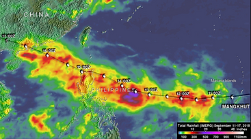
Date: September 23 - September 25, 2016
Maximum Wind Speed: 180 mph
Lowest pressure: 945 hPa (mbar); 27.91 inHg
Total fatalities : 134
Damage: $1.56 billion (2016 USD)
Affected nations: China, Taiwan, Philippines, Hong Kong, Vietnam
-
State Media announced that 2 people were killed in the Chinese province, Guangdong.
-
more than 2.5 million people have been evacuated in Guangdong and on Hainan island.
-
In Hong Kong, the storm strike several buildings and eventually shut down the city.
-
In the Philippines, 33 miners were killed and approximately 29 were missing after a landslide hit a mining site in Itogon in Benguet province based on the local report.
-
Officials of Hong Kong reported that the number of injured people are more than 200.
-
The government of the Philippines mentioned that there is a serious concern regarding the economic damaged caused by the typhoon especially on the farmland in Cagayan, a key agricultural province.
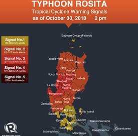
Typhoon Yutu (2018)
Date: October 21 – November 2, 2018
Maximum wind speed: 215 km/h (180mph)
Lowest pressure: 905 millibars (26.7 inHg)
Total fatalities: 6,340
Damage: $2.45 million
Affected nations: Philippines, Caroline Islands, South China,
and Northern Islands (Tinian and Saipan)
-
It made extensive landfall across Northern Marina Islands by dealing a catastrophic blow of damaging winds and torrential rainfall
-
It peaked winds of 180 mph, equivalent to a Category 5 hurricane.
-
It destroyed households, trees and power lines and caused roofs to collapse on Tinian and neighboring Saipan.
-
On Saipan, It killed two people and at least 133 other people were left injured.
-
Due to gust of Winds with 103mph, Saipan International Airport was closed and all flights were cancelled for 5 days causing inconvenience. Passengers and airport sustained significant damage: no refueling, inoperable navigation aids, flooding terminal along with the structural damage. Korean government evacuated 310 of citizens from Saipan to Guam by using military transport aircraft.
-
It totally destroyed concrete structures in southern Saipan and stripped areas of vegetation and made 55,000 of population to be left without electricity